Goals of the Project
Agricultural lands are intensively managed for high crop productivity. In the US Midwest, this is achieved through fertilizer application on a land that is significantly modified through tillage, and tile installation and channelization to increase the drainage in low relief topography. This process allows for agricultural machinery to be deployed in the field in a timely fashion in the spring, and support high crop productivity through the growing season. However, over time these same processes dislocate soil and carbon that is important to soil health, and transport excess nitrogen into waterways resulting in hypoxia in the gulf and other water bodies. This CINet project hones in on the role of “Critical Interfaces” that play a dominant role in overall functioning of the landscape resulting from the intertwined of hydrological, biological, ecological, geological, and chemical processes. These interfaces, which can be natural (e.g., depressions, floodplains) or human made (e.g., tile network, riparian buffers), can enhance or reduce landscape connectivity and serve as sites of interaction, amplification or dampening, and integration of material fluxes. Using a network of observational sites across the US Midwest that capture gradients of climate, topography, geologic history, and other landscape settings, the CINet project will provide a comprehensive understanding of how various components of a landscape serve to provide an integrated response. As a result, this research will provide unprecedented predictive capability for agro-ecosystems in relation to changes and impact of management and weather with implications for soil health and nutrient management.
Hypothesis and Objectives
Critical zone dynamics in intensively managed landscapes (IMLs) do not operate uniformly over time and space. They are intermittent and concentrated at critical interfaces (CIs) of exceptional importance for regulating material (i.e., water, sediment, carbon and nutrients) storage, transport and transformations. The central hypothesis of our research is that the dynamics of critical interfaces exert disproportionately large control on the overall dynamics of critical zones at the landscape scale; and since these critical interfaces are undergoing rapid and co-evolutionary transition due to human and weather stressors across spatial and temporal scales, they constitute the most limiting elements for predictive understanding to guide sustainable management of IMLs. The objective of the proposed research is to advance our understanding of critical interfaces individually as well as their interdependencies to overcome predictability bottlenecks of hydrobiogeochemical phenomena and their trajectories in IMLs from the small scale to the landscape scale, and from the event time scale to seasonal, inter-annual and decadal time scales. We will systematically look at the structure, evolution, and functioning of three interfaces that are particularly relevant to critical zone strongly affected by human action and weather: (i) the near land-surface; (ii) the active root zone; and (iii) the river corridor.
Timeline of Project
The CINet project is supported by the National Science Foundation from September 2020 to 2025.
Terminology
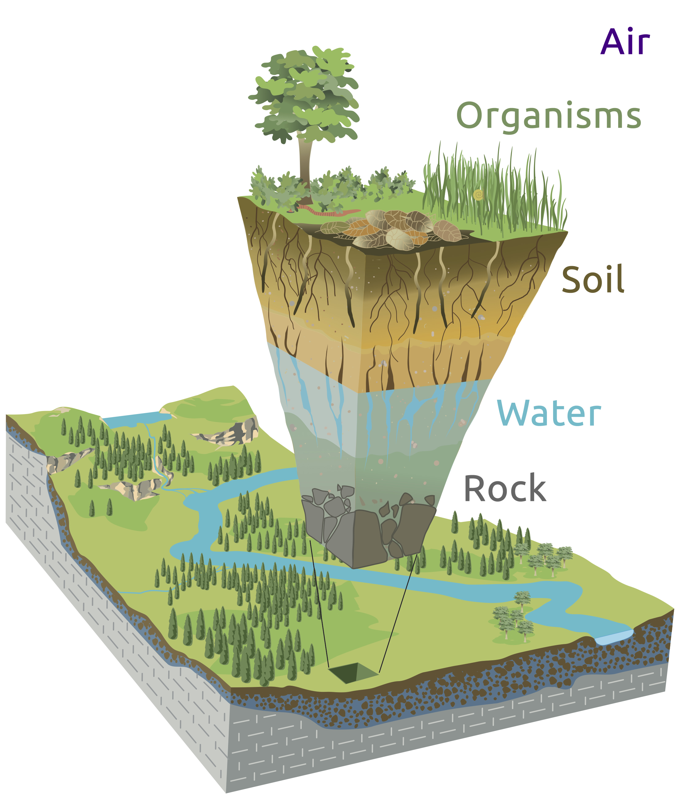
Critical Zone (CZ)
Earth’s permeable near-surface layer, from the top of the trees to the bottom of the groundwater.
It is a living, breathing, constantly evolving boundary layer where rock, soil, water, air, and living organisms interact.
These complex interactions regulate the natural habitat and determine the availability of life-sustaining resources,
including our food production and water quality.
Critical Interface (CI)
Transition areas situated between different boundaries of the Critical Zone (CZ). Examples
include transitions between the atmosphere and land surface, between hillslopes and river channels, and between the
biotic and abiotic interfaces in the root zone.
Intensively Managed Landscapes (IML)
Landscapes that support industrial agriculture.
Critical Zone Collaborative Network (CZCN)
An adaptive and responsive research network that supports investigations of the Earth’s Critical Zone.
Critical Interfaces (CI) Studied
Near-Surface
Active Root Zone
River Corridor